创建复合地图
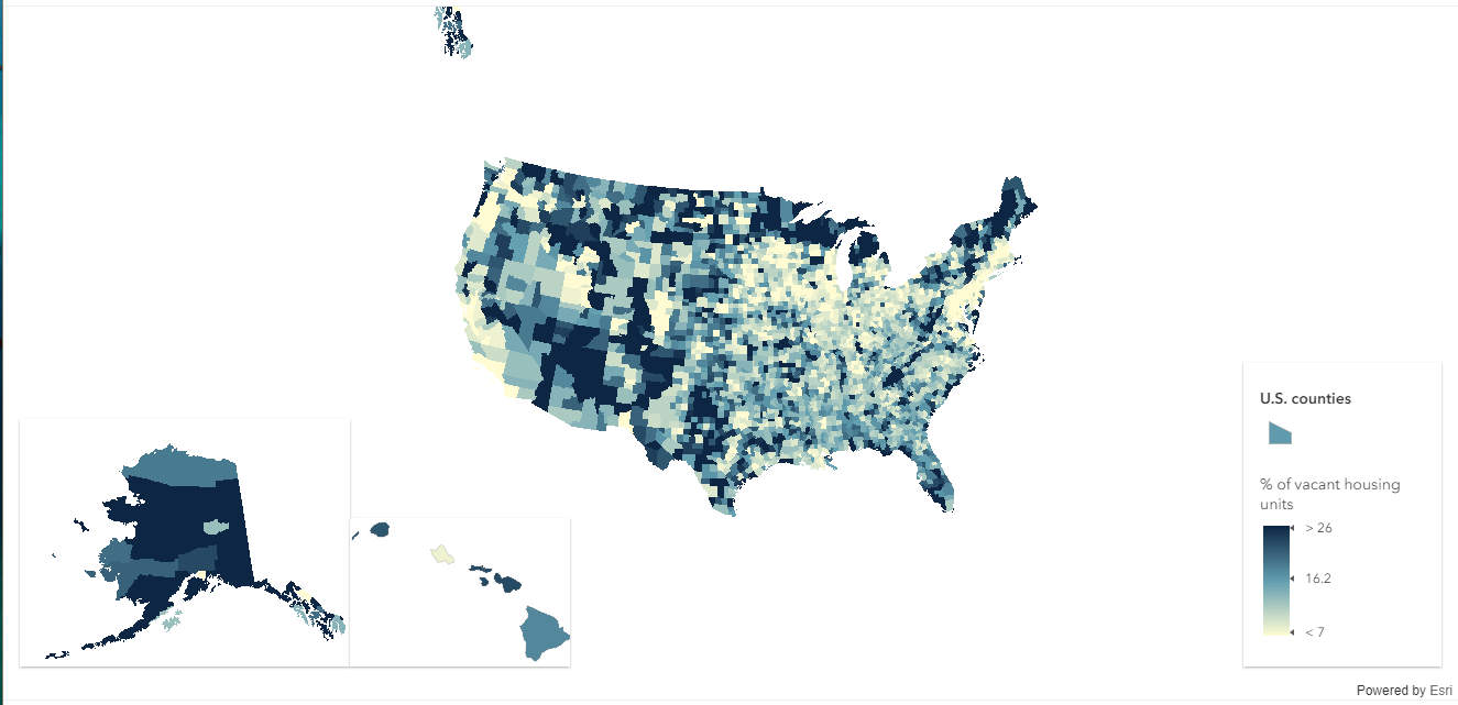
这个示例演示了如何使用三个复合 MapView 来创建应用程序,每个复合 MapView 具有不同的空间参考。主视图用于显示48个连续的美国州县,另外两个视图用于展示阿拉斯加和夏威夷(后两个在地理上距离美国主体领土较远,没有接壤)。将鼠标移到州县上可查看相关信息。
每个视图使用相同的地图实例,其中包含一个用 WebGL 渲染的 FeatureLayer。FeatureLayer 的一些特性是可变的,例如可以投影到不同的空间参考。
默认情况下,视图将使用底图的空间参考。如果没有指定底图(这个示例就没有指定底图),则会使用第一个添加的可操作图层的空间参考。显示地将设置视图的空间参考将会覆盖来自可操作图层的空间参考。
程序完整源代码:
<!DOCTYPE html>
<html>

<head>

  <meta charset="utf-8">
  <meta name="viewport" content="initial-scale=1,maximum-scale=1,user-scalable=no">
  <title>Create an app with composite views [beta] - 4.5</title>

  <style>
    html,
    body,
    #mainViewDiv {
      padding: 0;
      margin: 0;
      height: 100%;
      width: 100%;
    }

    #akViewDiv {
      padding: 0;
      margin: 0;
      height: 225px;
      width: 300px;
      background-color: rgba(255, 255, 255, 0.9);
    }

    #hiViewDiv {
      padding: 0;
      margin: 0;
      height: 135px;
      width: 200px;
      background-color: rgba(255, 255, 255, 0.9);
    }
  </style>

  <link rel="stylesheet" href="https://js.arcgis.com/4.5/esri/css/main.css">

  <script>
    var dojoConfig = {
      has: {
        "esri-featurelayer-webgl": 1
      }
    };
  </script>

  <script src="https://js.arcgis.com/4.5/"></script>

  <script>
    require([
      "esri/Map",
      "esri/views/MapView",
      "esri/layers/FeatureLayer",
      "esri/widgets/Legend",
      "dojo/domReady!"
    ], function(Map, MapView, FeatureLayer, Legend) {

      var layer = new FeatureLayer({
        portalItem: {
          id: "b234a118ab6b4c91908a1cf677941702"
        },
        outFields: ["NAME", "STATE_NAME", "VACANT", "HSE_UNITS"],
        title: "U.S. counties"
      });

      var map = new Map({
        layers: [layer]
      });

      /*********************************************
       * 主视图
       ********************************************/
      var mainView = new MapView({
        container: "mainViewDiv",
        map: map,
        popup: {//设置弹窗
          highlightEnabled: false,
          dockEnabled: true,
          dockOptions: {
            breakpoint: false,
            position: "top-right"
          }
        },
        extent: {//范围
          xmin: -3094834,
          ymin: -44986,
          xmax: 2752687,
          ymax: 3271654,
          spatialReference: {
            wkid: 5070
          }
        },
        spatialReference: {//空间参考
          // NAD_1983_Contiguous_USA_Albers
          wkid: 5070
        },
        ui: {
          components: ["attribution"]
        }
      });
      // 添加图例
      mainView.ui.add(new Legend({
        view: mainView
      }), "bottom-right");

      /*********************************************
       * 阿拉斯加视图
       ********************************************/
      var akView = new MapView({
        container: "akViewDiv",
        map: map,
        extent: {
          xmin: 396381,
          ymin: -2099670,
          xmax: 3393803,
          ymax: 148395,
          spatialReference: {
            wkid: 5936
          }
        },
        spatialReference: {
          // WGS_1984_EPSG_Alaska_Polar_Stereographic
          wkid: 5936
        },
        ui: {
          components: []
        }
      });
      // 添加到主视图
      mainView.ui.add("akViewDiv", "bottom-left");

      /*********************************************
       * 夏威夷视图
       ********************************************/
      var hiView = new MapView({
        container: "hiViewDiv",
        map: map,
        extent: {
          xmin: -342537,
          ymin: 655453,
          xmax: 231447,
          ymax: 1023383,
          spatialReference: {
            wkid: 102007
          }
        },
        spatialReference: {
          // Hawaii_Albers_Equal_Area_Conic
          wkid: 102007
        },
        ui: {
          components: []
        }
      });
      // 添加到主视图
      mainView.ui.add("hiViewDiv", "bottom-left");

      mainView
        .then(maintainFixedExtent)
        .then(disableNavigation)
        .then(disablePopupOnClick)
        .then(enableHighlightOnPointerMove);
      akView
        .then(disableNavigation)
        .then(disablePopupOnClick)
        .then(enableHighlightOnPointerMove);
      hiView
        .then(disableNavigation)
        .then(disablePopupOnClick)
        .then(enableHighlightOnPointerMove);

      // 固定视图范围
      function maintainFixedExtent(view) {
        var fixedExtent = view.extent.clone();
        view.on("resize", function() {
          view.extent = fixedExtent;
        });
        return view;
      }

      var highlight = null;

      // 设置鼠标滑过是高亮
      function enableHighlightOnPointerMove(view) {
        view.whenLayerView(layer).then(function(layerView) {
          view.on("pointer-move", function(event) {
            view.hitTest(event)
              .then(function(r) {

                // 移除先前高亮的
                if (highlight) {
                  highlight.remove();
                  highlight = null;
                }

                // 如果取到了要素,高亮并弹窗,如果没有,关闭弹窗
                var id = null;

                if (r.results.length > 0) {
                  var feature = r.results[0].graphic;
                  feature.popupTemplate = layer.popupTemplate;
                  id = feature.attributes.OBJECTID;
                  highlight = layerView.highlight([id]);
                  var selectionId = mainView.popup.selectedFeature ?
                    mainView.popup.selectedFeature.attributes.OBJECTID :
                    null;

                  if (highlight && (id !== selectionId)) {
                    mainView.popup.open({
                      features: [feature],
                      updateLocationEnabled: true
                    });
                  }
                } else {
                  if (mainView.popup.visible) {
                    mainView.popup.close();
                    mainView.popup.clear();
                  }
                }
              });
          });
        });
      }

      // 禁用视图中的导航操作
      function disableNavigation(view) {
        view.popup.dockEnabled = true;

        // 禁用弹窗的缩放
        view.popup.actions = [];

        // 当事件触发的时候,阻止默认行为
        function stopEvtPropagation(evt) {
          evt.stopPropagation();
        }

        // 禁用鼠标滚轮事件
        view.on("mouse-wheel", stopEvtPropagation);

        // 禁用双击事件
        view.on("double-click", stopEvtPropagation);

        // 禁用双击加Ctl
        view.on("double-click", ["Control"], stopEvtPropagation);

        // 禁用拖拽平移事件
        view.on("drag", stopEvtPropagation);

        // 禁用拖动加shift
        // 急用拖动加shift 加Ctrl
        view.on("drag", ["Shift"], stopEvtPropagation);
        view.on("drag", ["Shift", "Control"], stopEvtPropagation);

        // 禁用旋转和缩放
        view.on("key-down", function(evt) {
          var prohibitedKeys = ["+", "-", "_", "=", "a", "d"];
          var keyPressed = evt.key.toLowerCase();
          if (prohibitedKeys.indexOf(keyPressed) !== -1) {
            evt.stopPropagation();
          }
        });

        return view;
      }

      // 禁止用户通过单击打开弹窗
      function disablePopupOnClick(view) {
        view.on("click", function(event) {
          event.stopPropagation();
        });
        return view;
      }

    });
  </script>
</head>

<body>
  <div id="mainViewDiv"></div>
  <div id="akViewDiv" class="esri-widget"></div>
  <div id="hiViewDiv" class="esri-widget"></div>
</body>

</html>
程序运行效果:
(完)