标注子图层中的要素
当 labelsVisible 属性被设置为 true 的时候,标注将被应用到图层。labelingInfo 属性至少要包含一个 LabelClass ,LabelClass 定义了标注的表达式、摆放位置和符号属性。
程序完整源代码:
<!DOCTYPE html>
<html>
<head>
  <meta charset="utf-8">
  <meta name="viewport" content="initial-scale=1,maximum-scale=1,user-scalable=no">
  <title>MapImageLayer - label sublayer features - 4.6</title>

  <link rel="stylesheet" href="https://js.arcgis.com/4.6/esri/css/main.css">
  <script src="https://js.arcgis.com/4.6/"></script>

  <style>
    html,
    body,
    #viewDiv {
      padding: 0;
      margin: 0;
      height: 100%;
      width: 100%;
    }
  </style>

  <script>
    require([
      "esri/Map",
      "esri/views/MapView",
      "esri/layers/MapImageLayer",
      "dojo/domReady!"
    ], function(
      Map, MapView, MapImageLayer
    ) {

      /*****************************************************************
       * 创建渲染器
       *****************************************************************/

      var citiesRenderer = {
        type: "simple",
        symbol: {
          type: "simple-marker",
          size: 0.5,
          color: "white",
          style: "circle",
          outline: null
        },
        label: "Cities"
      };

      var statesRenderer = {
        type: "simple",
        symbol: {
          type: "simple-fill",
          style: "none",
          outline: {
            width: 2,
            color: "white"
          }
        },
        label: "State boundaries"
      };

      var countiesRenderer = {
        type: "simple",
        symbol: {
          type: "simple-marker",
          style: "none",
          outline: {
            width: 0.5,
            color: "white"
          }
        },
        label: "County boundaries"
      };

      /*****************************************************************
       * 创建图层 并设置标注
       *****************************************************************/

      var layer = new MapImageLayer({
        url: "https://sampleserver6.arcgisonline.com/arcgis/rest/services/USA/MapServer",
        sublayers: [{
          id: 3,
          renderer: countiesRenderer,
          opacity: 0.5,
          labelsVisible: true, //设置标注可见
          minScale: 9250000,
          labelingInfo: [{ //标注信息
            labelExpression: "[name]", //标注表达式
            labelPlacement: "always-horizontal", //标注摆放位置
            symbol: { // 标注符号
              type: "text",
              color: [255, 0,0, 0.7],
              haloColor: [1, 0, 0, 0.7],
              haloSize: 1,
              font: {
                size: 11
              }
            },
            minScale: 2400000,
            maxScale: 73000
          }]
        }, {
          id: 2,
          renderer: statesRenderer,
          opacity: 0.7,
          labelsVisible: true,
          labelingInfo: [{
            labelExpression: "[state_abbr]",
            labelPlacement: "always-horizontal",
            symbol: {
              type: "text",
              color: [0, 255, 255, 0.85],
              font: {
                size: 16,
                weight: "bolder"
              }
            },
            minScale: 18500000,
            maxScale: 9250000
          }, {
            labelExpression: "[state_name]",
            labelPlacement: "always-horizontal",
            symbol: {
              type: "text",
              color: [255, 255, 255, 0.85],
              haloColor: "gray",
              haloSize: 1,
              font: {
                size: 14,
                weight: "bold"
              }
            },
            minScale: 9250000,
            maxScale: 2400000
          }]
        }, {
          id: 0,
          renderer: citiesRenderer,
          labelsVisible: true,
          labelingInfo: [{
            where: "pop2000 > 500000",
            labelExpression: "[areaname]",
            labelPlacement: "above-right",
            symbol: {
              type: "text",
              color: "white",
              font: {
                size: 10
              },
              backgroundColor: [0, 0, 0, 0.5]
            },
            minScale: 18500000,
            maxScale: 4800000
          }, {
            where: "pop2000 > 500000",
            labelExpression: "[areaname]",
            labelPlacement: "above-right",
            symbol: {
              type: "text",
              color: "white",
              font: {
                size: 16
              },
              backgroundColor: [0, 0, 0, 0.5]
            },
            minScale: 4800000
          }, {
            where: "pop2000 <= 500000",
            labelExpression: "[areaname]",
            labelPlacement: "above-right",
            symbol: {
              type: "text",
              color: "white",
              font: {
                size: 7
              },
              backgroundColor: [0, 0, 0, 0.5]
            },
            minScale: 4800000
          }]
        }]
      });

      /*****************************************************************
       * 添加图层到地图
       *****************************************************************/

      var map = new Map({
        basemap: "satellite",
        layers: [layer]
      });

      var view = new MapView({
        container: "viewDiv",
        map: map,
        zoom: 5,
        center: [-100, 39]
      });

    });
  </script>

</head>

<body>
  <div id="viewDiv"></div>
</body>

</html>
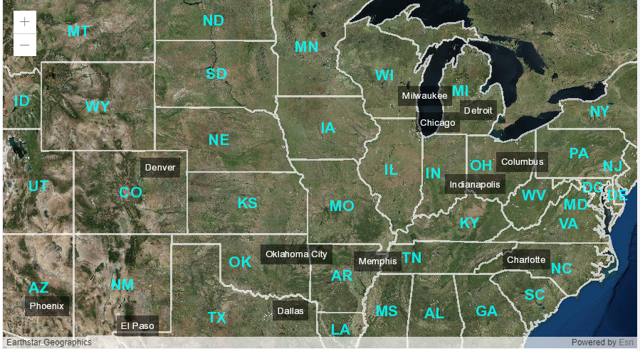
程序运行效果:
 沙箱地址:
沙箱地址:(完)